
Cycle Tour | Circumnavigation of the Iberian Peninsula, Including the Med. Coasts of S. France & S. Italy I Stage #4
Stage 4: Along the Northern Coast of Spain to the Portuguese Border
Northern Spain – Rugged Coastlines & Coastal Winds
Pedaling along Spain’s northern coast, I was greeted by dramatic cliffs, endless beaches, and the salty tang of the Atlantic. Cities like San Sebastián, Bilbao, Santander, and Gijón unfolded along the route, each offering its own unique character and history. The wind was constant, the climbs challenging, but the stunning vistas made every effort worthwhile.
From the Galician valleys to the pilgrim destination of Santiago de Compostela, the journey combined rugged natural beauty with centuries of culture. Finally, I crossed the Minho River, leaving Spain behind and entering Portugal, where new landscapes, villages, and coastal roads awaited.
Route Stages with GoPro Videos
Stage #4 I Day 16
Camping Alturar, Hendaye, (Basque Country) I France → Hostel Txalupa Getaria, Geteria (Basque Country) I Spain 📍 MAP
I fell asleep to the sound of rain and woke up to the same gentle rhythm on the tent’s fabric. Moving quickly, I dismantled the tent and carried it to the outdoor dishwashing area, where a shelter kept everything dry. I spread out my gear and began packing.
While folding the damp outer layer of my tent, another cyclist appeared, going through the same motions. His name was Erty, a Spaniard nearing the end of his own cycling trip. In just two days, he would be back home in the Basque Country, where his journey had begun.
Since we were heading in the same direction, we decided to ride together. As we pedaled, he told me he had completed several Caminos de Santiago, though always on foot. One of his treks had begun in Hendaye, on the picturesque bay of Txingudi, which forms part of the border between France and Spain.
There’s a service between Hendaye and Hondarribia on a traditional boat, used daily by locals and tourists alike and bicycles are allowed, up to five per trip. We skipped the boat and rode along the French Basque seafront, eventually crossing the Puente de Santiago over the Bidasoa River, the natural border between the two countries.
On the Spanish side, we reached Azken Portu, a neighborhood in Irun filled with shops selling wines, spirits, tobacco, perfumes, souvenirs, and clothing a warm Basque blend of culture and scenery.
From there, my journey officially joined the Camino del Norte, starting in historic Irún. Leaving the city, the route wound along the coastline near Errenteria, following parts of the EuroVelo 1 Atlantic Coast Route.
Between spectacular viewpoints, we rolled into Zurriola Beach also known as Gros Beach the main sand stretch in San Sebastián’s Gros neighborhood. The beach was long, nearly empty, with waves pounding the shore while surfers danced across them.
The cycle path continued along the Bay of Biscay, leading us into the heart of San Sebastián (Donostia in Basque), a city where elegant architecture, vibrant culture, and natural beauty coexist in harmony. Near the estuary where the rivers meet the sea itsasadarra in Basque we crossed La Zurriola Bridge over the Urumea River. Soon after, we reached another beach, a golden crescent of calm water with stunning views of Santa Clara Island and Monte Urgull.
Leaving Donostia, I stopped for a photo and realized I had taken a different street than Erty. Guided by Google Maps, I climbed into the wooded hills just outside the city, surrounded by quiet, lush green landscapes.
From Talai Mendi hill in Zarautz, I paused once more to admire the sweeping view over Zarautz Bay. Soon after, by coincidence, Erty and I crossed paths again. Together, we rolled downhill to Playa de Zarautz, the 'Queen of Beaches,' the longest stretch of sand in the Basque Country and a true surfers’ paradise.
After a few more photos, we continued to Getaria, a charming medieval fishing village on the Urola coast. We stayed at the Txalupa Getaria Hostel, which Erty had booked that morning. When I handed over my Canadian passport at check-in, the owner noticed and showed me his bracelet with a maple leaf a gift from a traveler he once met.
The hostel, designed for Camino de Santiago pilgrims, was spotless, well-organized, and run by a friendly host. We stayed in separate dorm rooms but later met to dry our tents in a grassy area near the Elcano Monument, a stone tribute at the entrance of Getaria’s historic center with spectacular coastal views.
That evening, we wandered through the narrow streets, stopping for an aperitif Coke for me, beer for him and tapas for both before picking up groceries at the supermarket. Back at the hostel, we cooked dinner in the communal kitchen and reviewed the next day’s route. By the time I climbed to my top bunk, I was ready to sleep.
Hostels aren’t really my thing; my little tent always feels more like home but I still drifted off quickly, knowing tomorrow would bring more sea views, more hills, and more pedaling into the Basque breeze.
Stage 4 - Day 17 Hostel Txalupa Getaria, Geteria → Camping Saturraran, Mutriku, Gipuzko (Basque Country) I Spain 📍 MAP
We woke up early at the Hostel Txalupa in Getaria, and right after breakfast we set off. We pedaled along the stunning coastline under a cloudy sky, but with no signs of rain, passing through the area of Zumaia. The town has two beaches, which are of significant interest to geologists because it's located within the longest stretch of continuous rock layers in the world.
Continuing along the coastline, we passed the area of Urola Ibaia and the town of Deba. From this point, my friend had decided to hike the trail that pilgrims on the Camino del Norte walk. He already knew it, having walked it on one of his own routes, and wanted to show me that stretch.
It was initially paved, then changed to paths characterized by gravel and stones, making it challenging to cycle and, in any case, impossible to navigate. So, for us, it was a "bike-hike," but it was definitely more like hiking with our bikes on the winding route from the sea up into the hills.
It was a long, beautiful stretch surrounded by green valleys and desert landscapes, but challenging due to its hilly terrain. However, it was worth it. Reaching the top was a viewing point at the "Behatokia Mirador," a short five-minute hike offering stunning views along the coastal route. There were also restrooms and a food truck with tables where we bought a drink and chatted with other pilgrims, but they were on foot.
Afterwards, we continued on a paved road that took us to Deba-Itziar at 225 meters, then downhill to the magnificent coastline with spectacular views, and then to the town of Deba, a popular stopover for pilgrims, offering a blend of historical sites.
In this town, my friend wanted me to buy the Camino de Santiago booklet. I had bought it for 10 euros at a tourist office, and it's also known as the pilgrim's credential, which is stamped at each stage to certify the journey.
In my case, he was sure that I hadn't had it stamped. That wasn't a reason for me, or, to say I did it, it was only because my friend had recommended it to me because I would have discounts on places to sleep, which are generally hostels. I don't particularly like that; I prefer my home my camping tent! So, he's sure I'll have a booklet with maybe three stamps at most. We'll see later on in my trip!
After picking up the booklet and a quick stop for lunch, we continued cycling through the town and finally to the coastal town of Matriku, located in the province of Gipuzkoa in the Autonomous Community of Basque Country in northern Spain.
After a short lunch break, we continued cycling to the coastal town of Matriku, in the province of Gipuzkoa. From there, Erty and I said our goodbyes he continued on to the next town, marking the end of his cycling journey.
I, on the other hand, stayed for the night and set up camp at Camping Saturraran, a beautiful, spacious site with friendly staff, just 200 meters from Saturraran Beach and close to the spectacular Flysch rock formations along the coast.
I wrapped up the evening with dinner at the campsite restaurant and, before going to bed, I checked the map for the next day's destination. Then, as the temperature dropped, I quickly slipped into my sleeping bag, wearing long pants and a long-sleeved shirt, and fell asleep.
Stage 4 - Day 18: Camping Satrruarar, Mutriku, Gipuzko → Pension Martinez, Bilbao I Spain 📍 MAP
This morning, before leaving the campsite, I met Yohanda at the restaurant. She’s a friend of the owner and works there. When I went to pay, the waiter smiled and said, “Yohanda already paid she’s treating you.” Apparently, she’d arranged it before I even arrived.
A few moments later, Chef Maurizio, an Italian who had settled in the area and worked both at the campsite and in other jobs, came to greet me. After a group photo and a warm exchange in Italian and English, I hugged them both and thanked Yohanda once again.
Leaving the campsite, the route followed the stunning coastline along a quiet road before turning inland through lush countryside and rolling hills, passing Mentreda and Markina-Xemein.
In Mallabia, I tackled a 3.2-kilometer climb from 234 meters to 440 meters at the La Trabakua sign. The average gradient was 4.6%, with a maximum of 8.9%—a solid workout for the legs! From there, it was a rewarding descent into Bilbao, the capital of Vizcaya (Biscay) and the largest city in the Basque Country.
Following the bike path along the Nervión River, I reached Pension Martinez, my accommodation for the night.
After checking in, I explored the city on foot, strolling along the river lined with elegant bridges, manicured gardens, and beautiful buildings. I also visited the iconic Guggenheim Museum, renowned for its striking architecture and contemporary art collection.
Before heading back, I stopped at a supermarket for dinner, then returned to my room. I ate, reviewed the next day’s route, and, happy after a wonderful day of pedaling, fell soundly asleep.
Stage 4 - Day 19: Pension Martinez, Bilbao → Camping Laredo, Laredo (Cantabria I Spain 📍 MAP
This morning, sunlight streamed through my window and a blue sky greeted me a perfect day for cycling. I had breakfast in my room with supplies I’d bought at the market the night before.
Once ready, I carried my bike kept in my room down two flights of marble stairs to the entrance, then climbed back up to fetch my panniers. The second trip down served as a warm-up before I’d even started pedaling!
With the bags secured, I followed the riverside bike path toward the El Carmen neighborhood of Barakaldo, where a large green globe sculpture caught my eye.
The path passed under a busy road, likely a highway, and I shared it with pilgrims walking the Camino del Norte, heading through Ortuella.
The route then wound through green valleys and open fields dotted with grazing horses, eventually reaching Zierbena on the western coast of Biscay.
From Playa de Arena, I continued toward Castro Urdiales. After a short railway tunnel, the trail clung to rugged cliffs, offering breathtaking views of the ocean.
Soon the path merged with the highway less scenic, but still lively with pilgrims on foot bound for Ontón. A steady climb gave way to a steep 10% descent into Mioño, then on to Islares, a coastal town known for its right-handed beach break, popular with intermediate surfers.
Leaving the shore, I rode inland through Liendo and Tarrueza before arriving in Laredo, a Cantabrian coastal town nestled between Bilbao and Santander.
I set up camp at Camping Laredo, a clean, well-run site with a small market, a heated pool with a lifeguard, and a playground. After pitching my tent and finishing the usual camping chores, I walked to a nearby stable to see the horses.
They offered rides along the beach and through the forest if I’d arrived earlier, I would have joined one.
Dinner was at the campground restaurant, where I also charged my electronics. Normally, I pay to use the designated charging stations, but since I was already there for dinner, I made the most of it.
By the time I returned to my tent, rain was falling. I checked the next day’s route on Google Maps and Komoot, then drifted off to sleep to the gentle rhythm of raindrops on canvas.
Stage 4 - Day 21: Camping de Comillas, Comillas (Cantabria) → Hotel Argüelles, Ribadesella (Asturia) I Spain 📍 MAP
This morning the sky was low and gray, pressing close to the earth. After packing my tent, I unlocked Girasole, reattached the panniers, and set off along the quiet coastline. Rugged cliffs plunged into the restless ocean, and the air smelled faintly of salt and wet grass.
I soon reached the 15th-century Puente de la Maza, a graceful medieval bridge linking San Vicente de la Barquera to its surroundings. Beside it, an iron statue of a pilgrim and a wooden bench inscribed “Caminos Lebanon” reminded me of the far-reaching influence of the Camino de Santiago. From the bridge, sweeping views stretched over Oyambre Natural Park, the town’s waterfront, and the Río Escudo estuary, its still waters reflecting the gray sky.
Following the familiar yellow arrows and scallop shell signs, I cycled through Pesués, El Peral, Colombres, Bustio, and La Franca. At Buelna, the Camino offered two routes: a rugged coastal path, tricky even on foot, or the main road. I took the road, which meandered gently through lightly trafficked terrain, offering smooth climbs and descents. Beyond Pendueles, the route narrowed to a gravel track winding over grassy hills, past grazing cows and moss-covered stone walls, opening onto the Porrúa plain with its country houses and the small Church of San Julián and Santa Basilisa.
About fifteen kilometers from Llanes, Playa de San Antolín appeared: a wide, wild beach where a few surfers rocked gently in the waves. I paused at a lookout, feeling the cool wind on my face, and snapped a few photos before continuing along a coastal bike path toward Nueva. There, a dramatic viewpoint revealed a natural arch rising from the sea, the beaches below empty under heavy clouds.
In the afternoon, I arrived in Ribadesella, a lively town along the northern coast of Asturias. Green hills sloped gently toward the sea, and the Sella River divided the town. A single bridge connected the historic center narrow cobblestone streets, centuries-old houses, flower-filled balconies, and a bustling marina to the modern promenade and the sandy stretch of Playa de Tito Bustillo.
My lodging, Hotel Argüelles, was modest but welcoming, located in the old quarter near the port. The manager stored Girasole safely before showing me to a small room with a view over red-tiled rooftops.
I wandered the streets for a while; down at the harbor, colorful fishing boats rocked in calm water. When a light drizzle began, I returned to the hotel, stopping at a few shop windows and a small supermarket for dinner supplies.
Back in my room, I ate quietly while listening to the steady patter of rain. Before sleep, I checked Google Maps and Komoot for tomorrow’s route, then drifted off to the sound of water on the window.
Stage 4 - Day 22 Hotel Argüelles, Ribadesella (Asturia) → Hotel Avenida, Gijón (Asturia) I Spain 📍 MAP
When I woke, the forecast had been right rain. Breakfast was simple: a bottled cappuccino, two croissants, and a banana from last night's shopping.
I set off into the drizzle, weaving through the eastern side of the historic center, over the Sella bridge, and westward past San Esteban, Caravia Alta, and Prado. Pilgrims in waterproof capes trudged steadily along, each greeting me with a cheerful “Buen Camino!”
At times, the road opened to the ocean, where a gray sky pressed low against the horizon. Rain fell in a fine, steady veil, stippling the surface with countless floating rings—appearing, expanding, and dissolving in an instant.
The sea, restless and slow-breathing, had deepened to a bruised blue streaked with white foam. The air smelled faintly of salt and wet stone; the wind carried the sound of waves sometimes a distant, muffled roar, sometimes a sudden crash against the rocks.
At Playa de la Espasa, I paused to photograph the empty, wind-swept beach. Waves curled and broke with a hollow thud, throwing spray into the air as though the ocean itself were breathing harder in the rain. The place felt alive, untamed, yet calm in its solitude. The route was crowded with pilgrims; since I started the Camino del Norte, I've only encountered two other cyclists.
Near Colunga, famed for its dinosaur footprints, I passed the turnoff for the Jurassic Museum of Asturias but didn't stop the wet air discouraged lingering. In the town, I found shelter under the covered entrance of an empty house, resting on a stone bench until the heaviest downpour passed.
From there, the road climbed into greener, more rural scenery: scattered houses perched on slopes, fields bounded by stone walls, and cows grazing lazily.
Skirting Villaviciosa, the “Apple Capital” of Asturias, I passed the Ría de Villaviciosa Partial Nature Reserve a calm estuary where river and sea met beneath a misty drizzle. Eucalyptus trees lined the road, their rain-darkened bark nearly black. Outside a small carpentry workshop, freshly cut logs were stacked in neat rows.
The air was saturated with the scent of rain and fresh grass drifting over wide, open fields. The road rose and fell in long climbs and steep descents, carrying me through El Pedrosu and La Esperanza before finally delivering me to Gijón, the largest city in Asturias, still wrapped in unrelenting rain.
At the Hotel Avenida Gijón just 550 meters from Playa de Poniente I stored my bike, hung my wet clothes to dry, and surrendered to a long, hot shower.
I left my room only long enough to pick up dinner at the supermarket, eating it back in the warmth of the hotel. No sightseeing tonight after so many hours pedaling through the rain, I had no desire to be caught in it again; the day had provided more than enough. With the next day's route checked on Google Maps and Komoot, I drifted off to sleep to the steady rhythm of rain against the window
Stage 4 - Day 23 Hotel Avenida, Gijón (Asturia) → Camping Yolimar, Cudillero ( Austias)) I Spain 📍 MAP
I woke up to a clear sky, the kind that makes you eager to get moving. Breakfast was simple: bread, fruit, and yogurt I had bought at the supermarket the night before, eaten by the open window as the cool morning air drifted in.
Downstairs, I collected my bike from the storage room, exchanged a cheerful “good day” with the receptionist, and rolled onto the bike path outside the hotel. Gijón was quiet in the morning light. I wandered through the old town without a plan, letting the narrow streets and the scent of the sea guide me.
Soon the seafront opened up, leading me to Playa de Poniente golden sand, calm waters, and a stretch of beach that, though built in the mid-'90s, had already become part of the city’s rhythm. Leaving Gijón behind, the road widened for cyclists before narrowing into smaller lanes that felt like secret paths.
The yellow scallop shells and arrows of the Camino appeared everywhere—on posts, walls, and small concrete markers painted in the classic blue-and-yellow tile design. I passed farmland, grazing horses, lazy cows, and tall cornfields swaying in the breeze.
The villages were small and quiet, each with its own understated charm. A low underpass led me to Corvera, where a rural bike path carried me naturally into Avilés and along its long estuary promenade. The air smelled of river and salt, and the views stretched wide and endless.
Across the water, the Oscar Niemeyer International Cultural Centre rose gracefully with bold white curves accented in red and yellow, monumental and almost otherworldly against the landscape. I paused to lean my bike against the railing and take photos of the structure and the surrounding estuary.
Continuing along the path to the port of Avilés, boats swayed gently at their moorings, and the 30-meter-tall sculpture Avilés by Benjamin Menéndez stood like three silent lighthouses pointing to the sky.
The road climbed to Piedrasblancas, then descended again to Soto del Barco, where I crossed the broad Río Nalón. Skirting Muros de Nalón, the coast drew me onward to my destination: Cudillero, a picturesque fishing village squeezed between mountains and sea.
I arrived at Camping Yolimar, almost empty in the low season, and set up my tent in the perfect spot. Dinner was at the Restaurante Yolimar next door a simple, hearty seafood meal, exactly what I needed after a long day of cycling.
Back at the campsite, I followed my usual routine: checking the next day’s route, organizing my gear, and finally slipping into my sleeping bag to the quiet sound of the distant sea.
Stage 4 - Day 24: Camping Yolimar, Cudillero ( Austias) → Hostal El Pinar (North Galancia), Ribadeo ) I Spain 📍 MAP
This morning I woke up at Camping Yolimar to clear blue skies. I packed up my tent, loaded the panniers back onto the bike, and set off on a route that kept me climbing and descending all day, always through rolling green hills and quiet countryside.
After leaving the campsite, I passed through Martín de Luina and soon reached Soto de Luiña, a small village along the Camino del Norte. I hadn’t had breakfast yet, so I stopped at a café with outdoor tables. I wasn’t the only one—several pilgrims with heavy backpacks were gathered there, sharing the same morning pause.
From there, the road followed the coast, carrying me through the villages of Valdredo, Novellana, Valdés Tablizo, Ribón, and Camero, before dropping into Luarca, a charming fishing port. Later, I reached Navia, perched on the Ría de Navia.
Crossing the bridge, I paused to take a photo and chatted briefly with a friendly pilgrim. The bridge was alive with walkers, each on their own long journey.
From Castropol, I followed a rural bike path that eventually led to the Puente de los Santos, crossing the River Eo and marking the entrance into Galicia. The crossing was unforgettable: wind whipping across the deck, the sea opening wide beneath me, and a race unfolding along the distant shoreline.
Once across, quiet farm paths led me to Ribadeo, in northern Galicia. My stop for the night was Hostal El Pinar, conveniently near both the beach and the town center.
After checking in with the friendly staff, I left my bags in a spotless room and wandered through the hostel’s spacious gardens, which featured barbecue areas and a small playground.
Dinner was simple, with a restaurant just across the road. Later, back in my room, I went through my usual routine of checking the next day’s route before settling into bed. Sleep came quickly, another full day of pedaling behind me
Stage 4 - Day 25; Hostal El Pinar (noirth Galancia), Ribadeo → Albergue de Peregrinos de Baamonde, Begonte I Spain 📍 MAP
Mi svegliai alle 7:00 sotto un cielo limpido e soleggiato. Dopo essermi preparato, attraversai la strada dall’hotel per una colazione veloce in un café-ristorante, prima di lasciare definitivamente Ribadeo.
Meno di 25 chilometri più avanti, attraversai Miguel de Reinante e Barreiros, tra la foce del fiume Masma e il territorio di Ribadeo. L’Atlantico lentamente si allontanava dalla strada, mentre il percorso mi portava nell’entroterra della Galizia.
Il paesaggio cambiò in colline ondulate e piccoli rilievi montuosi, verdeggianti e tranquilli, pieni di salite e discese. Lungo la strada passai per Lourenzá, Mondoñedo, Abadín e la storica Vilalba, dove mi fermai brevemente davanti al suggestivo cimitero neogotico di Goiriz.
Verso sera raggiunsi la mia destinazione: Baamonde, piccolo villaggio del comune di Begonte, in provincia di Lugo. Tradizionale tappa del Camino del Norte, Baamonde è situato a un crocevia frequentato dai pellegrini in transito.
Alloggiavo al Baamonde Pilgrims’ Hostel, un semplice albergue pubblico ricavato da un vecchio deposito di diligenze, riservato esclusivamente ai pellegrini.
Al check-in, la donna alla reception chiese di vedere il mio passaporto da pellegrino. Quando glielo consegnai, rimase sorpresa: c’era solo un timbro, insolito per qualcuno così vicino alla fine del Camino del Norte.
Le spiegai che non colleziono timbri per riconoscimenti; la vera soddisfazione è completare il percorso, come faccio con tutti i miei viaggi in bici. Il libretto l’avevo comprato all’inizio del viaggio, su consiglio di un altro cicloturista, e doveva servire solo da souvenir, con pochi timbri.
L’albergue era pulito e ordinato, anche se richiedeva di lasciare la bici all’esterno, cosa che non mi ha reso felice: per me è parte essenziale del Camino, come lo zaino per un pellegrino a piedi.
Dopo essermi sistemato, gironzolai per il villaggio in attesa dell’apertura di un piccolo supermercato, frequentato da altri viaggiatori e pellegrini, molti dei quali parlavano italiano.
Comprai la cena, la scaldai nel microonde dell’albergue e passai un po’ di tempo nella sala comune a ricaricare l’attrezzatura e controllare la mappa per il giorno successivo.
Quando la sera calò, salii nel mio letto a castello i posti inferiori erano tutti occupati e caddi rapidamente in un sonno profondo, con un’altra giornata di pedalate alle spalle.
Stage 4 - Day 26: Albergue de Peregrinos de Baamonde, Begonte → Camping As Cancelas, Santiago de Compostela I Spain 📍 MAP
I woke up earlier than usual. The pilgrims sharing the large room with me had already risen at dawn, and it was still dark outside. I got up as well, even though I wasn’t in a hurry I didn’t want to pedal in the dark. After a quick shower, I went down to the dining room and had a leisurely breakfast.
When there was enough light, I left the Albergue de Peregrinos de Baamonde and joined the road shared by cars and pilgrims. Soon I reached Toar, a small hamlet in Guitiriz, where a familiar blue sign with the yellow scallop shell of Santiago directed me onto a short, shaded path. The way was peaceful, lined with thick vegetation and at times running close to the Río Parga.
From there, the path opened onto a quiet country road through Guitiriz, past rustic houses and swampy fields. I pedaled through the serene landscape, meeting no one along the way.
The route continued along a scenic provincial road, winding between rolling hills, distant low mountains, and patchwork fields. I passed through small towns Mesia, Frades, and Marquino always accompanied by the quiet rhythm of my pedals.
Eventually, an unexpected gravel trail led me to Camping As Cancelas, perched on a small hill in Santiago de Compostela, the capital of Galicia. After checking in, I pitched my tent in a quiet, beautiful spot surrounded by trees and greenery, with a wide view over the valley below. The campsite felt like a little paradise, complete with a swimming pool, restaurant, bar, and even a shopping center just 300 meters away, where I went to buy my dinner.
The evening passed with a peaceful walk around the nearly empty campsite—low season now before I sat down to eat. I could have taken the nearby bus into Santiago to see the city by night, but I decided to wait.
Tomorrow, I will take my beloved bicycle, Girasole, and finally reach the Cathedral of Santiago: the destination of the Northern Camino for most pilgrims.
For me, however, it won’t be an ending but the beginning of the next chapter of my circumnavigation of the Iberian Peninsula. I fell asleep filled with anticipation, eager to see the magical Cathedral and to celebrate the end of my unforgettable Camino del Norte.
Stage 4 - Day 27: Camping As Cancelas, Santiago de Compostela → Camping Play Samil, Vigo I Spain 📍 MAP
This morning, like most mornings, I woke very early. The days are getting shorter, and with evening arriving sooner, my cycling hours are shrinking. Covering all the kilometers I’d like in a day isn’t easy, but I can’t complain.
After dismantling the tent and pausing to watch the sunrise, I packed my panniers, secured them onto the racks, and headed to the campsite cafeteria for breakfast.
A short descent brought me quickly into the heart of Santiago de Compostela, where the Cathedral rose before me in all its grandeur Romanesque in design, crowned by a majestic Gothic façade. I wasn’t alone in my awe. Pilgrims from all over the world filled the square, sharing the same joy at completing their Caminos. We exchanged congratulations, snapped photos for one another, and celebrated the moment together.
For me, the Cathedral marked the end of more than 800 kilometers through the Basque Country, Cantabria, Asturias, and Galicia lands of breathtaking landscapes and rich cultural heritage. It was the conclusion of my Northern Way, but also the start of a new adventure: the Portuguese Coastal Way, which would carry me to Porto.
While for most pilgrims Santiago is the finish line, for me it became another starting point, part of my longer journey around the Iberian Peninsula.
After a last glance at the Cathedral, I rolled out of Santiago’s cobbled old town, passing through Ames, and joined a path where pilgrims walked with backpacks—some heading my way, others in the opposite direction. The Camino, well marked with its familiar scallop shells, soon merged with a road toward Valga in Pontevedra.
In Pontevedra, I admired the medieval Ponte do Burgo and the views of the Lérez River before crossing the modern Ponte de los Correntes, a pedestrian and cycling bridge. Its bike path ended abruptly after ten minutes, forcing me to rely on Google Maps to reconnect with the Camino along the riverbanks. From there, the route carried me through Soutomaior, with views of the coast and a small beach, then onward toward Cabanas and Rande.
By afternoon, I reached Vigo, cycling through its historic center and past its bustling fishing port one of the largest in Europe. The city sits on the Ría de Vigo estuary, partly sheltered by the Cíes Islands, which form a protected natural park.
A few kilometers later, I arrived at my destination: Camping Playa Samil. Though small, it felt welcoming, set directly across from the wide Samil Beach with sweeping views of the Cíes archipelago. After checking in with the friendly staff, I pitched my tent and later strolled along the seafront, lined with shops and restaurants.
I picked up dinner, which I ate back at the campsite. As the sun set, I crossed the road to Samil Beach a long ribbon of white sand and crystal-clear water.
With the sky clear, I could even see the Cíes Islands silhouetted on the horizon. Back at camp, as always, I checked the next day’s route and fell asleep to the gentle rhythm of the waves.
Stage 4 - Day 28: Camping Play Samil, Vigo I Spain → Parque de Campismo de Belinho, Belinho I Portugal 📍 MAP
This morning I thought I’d wake to a sunny day after the glowing sunset of the night before, but instead the sky was a faded yellow, the sun a dim red, and the air thick with smoke from wildfires burning somewhere in Portugal.
After my usual pre-departure routine, I set off pedaling through the smoky streets of Vigo, heading northwest. Soon I left the city behind for landscapes where sea and mountains meet, passing small towns like Nigrán, known for its beautiful beaches Playa América being one of the largest and most striking.
The flat coastal route led me on to the medieval port town of Baiona, where the harbor was full of boats, the sandy beach stretched wide, and a promenade circled the Monte Boi peninsula crowned by the Monterreal Castle.
The Camino Portugués Coastal here runs directly along the shore, with wild ocean views and endless beaches. In Oia, the smoke was so heavy that I stopped at a gas station to buy a mask. They didn’t sell any, but the attendant kindly gave me a packaged one he had stashed away.
From there, the road hugged the coast through breathtaking scenery all the way to the fishing town of A Guarda. From its small port I boarded a short motorboat across the Minho River, crossing into Portugal. The ride was calm and scenic, the captain friendly, and pilgrims with backpacks were waiting to take the same crossing after me.
On the Portuguese side, I soon reached Vila Praia de Âncora, a charming fishing village with a seaside promenade overlooking the Atlantic. I stopped to take photos of Forte da Lagarteira (Âncora Fort), the fishing boats, and the sweeping beaches, even though the smoky sky muted the colors.
Eventually, I reached Viana do Castelo, where the Lima River meets the sea. I pedaled through its historic center, weaving along narrow streets lined with cafés and shops, before riding to the port to see the Gil Eannes, a restored hospital ship now serving as a museum and youth hostel.
For the last stretch, I followed the waterfront, crossed the Eiffel Bridge over the Lima, and continued along a cobbled path into Castelo do Neiva. There I met a young pilgrim who had started the Portuguese Way in Porto and was headed to Santiago.
After a short chat, I continued on to Parque de Campismo de Belinho, in the municipality of Esposende. This coastal town and municipality in the Braga District of northern Portugal, situated at the mouth of the Cávado River on the Atlantic coast.
I set up my tent in the quiet, low-season campsite, accompanied only by a few wandering cats. Just 200 meters away lay Praia do Belinho, north of the Cávado River mouth and stretching toward the Neiva River my final view of the day.
Stage 4 - Day 20: Camping Laredo, Laredo (Cantabria) → Camping de Comillas, Comillas (Cantabria) 📍 MAP
Then I took down the tent, which had been left to dry, packed it away, and loaded the panniers onto the bike racks. Setting off, I first passed the stables, then rolled through the fishing village of Laredo.
From here, pilgrims on foot take a small boat across the narrow bay separating Laredo from Santoña—two towns with very different characters. For cyclists, however, the coastal alternative is a steep, rugged mountain trail, better suited to hiking than riding, especially with a loaded bike. I chose instead to cross the Ría de Treto via the bridge.
On the opposite bank, Google Maps guided me along a winding dirt path, Calle La Tejera, which ran parallel to the highway in the distance. The long, steep climb forced me to push my bike for much of the way.
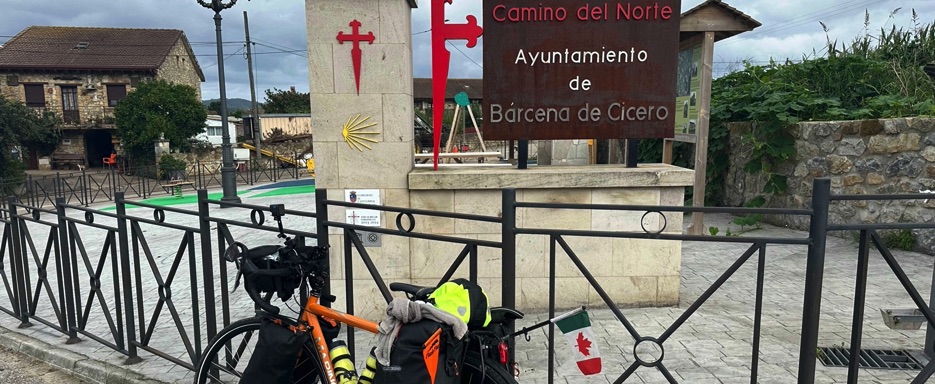
At the top, I arrived in the rural area of Bárcena de Cicero, another stop for pilgrims on the Camino de Santiago del Norte. At the corner of a country road stood a “Camino del Norte” sign beside a small farm where cows and chickens grazed peacefully.
The dirt track eventually joined the N-634, whose rolling terrain carried me through green landscapes and open countryside. I passed Beranga, a small village, then Praves de Medio Cudeyo, before reaching Solares, not far from Santander.
Rather than head into Santander, I continued inland, surrounded by a tranquil mix of lush nature and cultivated fields.
Before La Encina, I came across a wonderful bike path, and from the Castañeda area I followed a beautiful route I’d discovered by chance—the Vía Verde del Pas (Green Way of the Pas). This trail ran alongside the Suscuja River, through golden wheat fields, and finally reached Pomalungo.
From there, local roads with gentle climbs and descents led me past green hills dotted with grazing animals and farmland. I passed through Varga, Sierrapando, Torrelavega, Puente San Miguel, Vispieres, Santillana del Mar, Oreña, Cóbreces, and Ruiloba.
The route then returned to the coast, ending in Comillas, famous for its modernist architecture, including Gaudí’s Capricho. Crossing the bridge, I arrived at the Comillas campsite.
It was low season, so the grounds were quiet, though the small on-site supermarket was still open. I bought soup to reheat and a can of beans for dinner. The shopkeeper, Amalia, was warm and friendly; she helped me heat the food in the microwave, provided a plate and fork, and even arranged everything on a makeshift tray she’d fashioned from a cardboard box so I could carry it easily back to my tent. It felt like a little takeaway treat.
After eating, I strolled along Comillas Beach, which was surprisingly lively and strikingly beautiful. Back at the tent, I did my usual evening chores and soon fell asleep.