
I have always dreamed of cycling the entire Iberian Peninsula and going from the sunny shores of the Mediterranean to the lush hills of the Atlantic Ocean crossing the wild expanse of the French Pyrenees mountain range which separates the Iberian Peninsula from the rest of Europe stretching between France and Spain.
Trip details
My epic solo on a fully self-supported bike tour is a full circumnavigation trip around the Iberian Peninsula took in the whole of Spain and Portugal and a crossing of the Pyrenees.
Start and end of the trip: Ventimiglia, Italy
Kilometers traveled: Cycling counterclockwise 5,714.23
Daily average: 95.24 KM
Duration and period: 60 days without a single day of rest, from August 22nd to October 20th 2024
Nations crossed: Along the entire perimeter of the Iberian Peninsula: Spain, The French Pyrenees from the Adriatic Sea to the Atlantic Ocean and Portugal, I Pedaling also from: taly and France
About the adventure
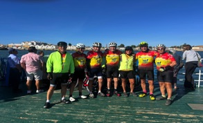
The journey with the two wheels started by taking the train from Milan Central Station to Ventimiglia, a charming little town on the coast of the Italian Riviera and is located right on the coastal border between France and Italy.
I started in Ventimiglia, the last town in the Italian Riviera before hitting the French border and continues with the name of French Riviera also known as the Côte d'Azur that overlooks is the Mediterranean coastline of the southeast corner of France. Just past the Italian border the first French town of Menton cycling along the coastal road The Basse Corniche, the embraces the closest to the sea which links to Monaco, Monte-Carlo and Nice.
There are three panoramic roads are: The Basse Corniche, The Moyenne Corniche and The Grande Corniche and all of them run parallel to each other with differences in altitude between them.
After passing the luxurious resorts of Monaco and Monte-Carlo and the famous Promenade des Anglais in Nice, a series of panoramic balconies follow along the and amazing coastal road which winds its way through the varied landscapes with the slopes but the too challenging and passes through lots of little fishing villages and other major French towns beside the Mediterranean sea.
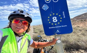
Then continuing on the splendid Corniche d'Or, a winding coastal road that connects Cannes to Saint-Raphaël and to Mandelieu-La Napoule passing then through the towns of Toullon, Marseille, and Grande Motte and from this point I started pedalling on the cycle path of the EuroVelo 8 (Mediterranean Route) reaching thes easide resort of Le Barcarès bordering the Mediterranean Sea on the slopes of the Pyrenees Orientates.
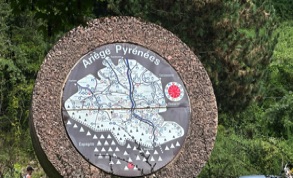
Leaving the Adriatic Sea and left behind Barcarès I crossed the French Pyrenees ending in the city of Bayonne where the Adour and Nive rivers meet, few kilometres from the Atlantic Ocean in the Basque Country region of southwest France.
From the spectacular French Atlantic coast of the Basque Country I passed the seaside resort of Angelet, Biarritz, a paradise for surfers, to the fishing village of Saint-Jean-de-Luz and then crossed the bridge which is located above the mouth of the river Bidasoa which connects Hendaye to Irun is a Spanish city that borders the Cantabrian Sea in the Basque Country and is located on the border between France and Spain. It is also the starting point of the Camino de Santiago
Cycling the Camino del Norte from east to west from Irún to Ribadeo to the Santiago de Compostela Cathedral
And from this point I cycled The Camino del Norte, also known as “Camino de la Costa” or “Camino de Santiago del Norte” is an ancient pilgrimage routes of more than 800 kilometers that start in the town of Irún runs form east to west along the northern Spanish coastline often referred to as "Green Spain" leads to the the capital of Santiago de Compostela in Galicia.
This is a route where you can appreciate the landscapes and nature with a green setting that embraces the wild and rugged ocean coast, pristine sandy beaches, fishing villages and expanses of green meadows. It has a vast network with numerous variations of routes that intertwine with each other and lead to the same destination, some run along the ocean, others are more inland, but the presence of the ocean is never too far away. The route is well marked with yellow arrows and shells that indicate the direction and develops on asphalt roads or dirt roads on cycle paths with continuous "ups and downs" and without flat sections with challenging climbs. These are truly spectacular and challenging days also for the climatic reasons in which the weather changes rapidly, it is often humid, cold, foggy and sunny.
This spectacular route passes through the regions of the Basque Country, Cantabria, Asturias and Galicia. In addition to the large cities of: Sebastián (Donostia), Bilbao, Santander, Gijón and Ribadeo on the Atlantic Sea located in the province of Lugo in Galicia
From Irún I cycled through the Atlantic regions up to the charming coastal town of Ribadeo then heads inland the landscape changes from a coastal path to a farmland and mountainous views, up the beautiful Lourenzá valley and through Mondoñedo, before tackling some challenging climbs that reach 540 m in altitude, passing through the towns of Abadin, Vilalba, Baamonde and with various ups and downs to the city of Santiago de Compostela, a place of pilgrimage and the final point of the Camino de Santiago. It is the capital of the north-western region of Spain, Galicia.
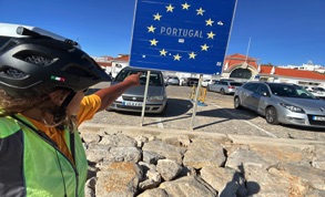
After I left behind the Cathedral of Santiago de Compostela and I followed part of the route of the famous Camino Portugues/Portuguese Coastal Way leads to small villge of Padrón, continuing towards to il fiume Rio Lerez meets the Atlantic Ocean at Pontevedra to Redonela, Virgo and the historic coastal town Baiona (famous for big heplc were Christopher Columbus landed after his first voyage to America),and continuing to follow the coast to the town of A Guarda I leave Spain taking a 15 minute ferry across the River Minho to the town of Caminha in Portugal.
Cycling the Portuguese Way or Camino Portugués
After I left behind Spain and leaving Caminha behind I cycled along the beauty of Portugal's wild Atlantic coast from north to south following the Camino Portugues Coastal Route, the EuroVelo 1 "Atlantic Coast Route" and other fantastic inland paths or roads passing through the city of Porto the picturesque fishing village of Nazaré, it is a world-famous surfing destination famous for its giant waves at Praia do Norte beach, Figueira da Foz, Torres Vedras and Lisbon.
After visiting Lisbon I continued cycling until I reached the Belem ferry Terminal in the western side of Lisbon I took a ferry to cross the Tagus River to the riverside village of Trafaria where the Tagus river meets the sea. Then I cycle in the hidden germ of the Costa da Caprica on the Setúbal Peninsula has stunning wide, flat beaches and there so many cycle routes to explore.
Then, a short ferry ride from Setúbal to Tróia peninsula in the Alentejo region, the port city of Sines, and then enter the Vicentina Natural Park, the beautiful coast in the country, through the towns of Vila Nova de Milfontes, S.Teotónio, close to the boarder of the Algarve (located a few kilometers away from Zambujeira do Mar in the coast). Then, Odeceixe is a small village by the Seixe River, which forms the border between the provinces of Alentejo and Algarve. It's the first Algarvian village on the Vicentine coast region.
After leaving Odeceixe behind, I cycled inland through the rolling hills of the Algrave countryside arriving at the village of Bensafrims before reaching the western part of the Algrave where I then cycled on the Ecovia Litoral fom the town of Logos.
Cycling the The Atlantic Coast Route The Ecovia Litoral which is part of the Eurovelo 1 in the Algarve region
The 220-kilometer cycle path that follows the entire coastline of the Algarve region, South Portugal that connects from the west Cabo de São Vincente to the west a Villa Real de St. Antonio on the border of Spain.
Upon arriving in the western part of the Agrarve the route takes in varied terrain from flat cycle paths to rolling hills and local roads with little traffic amidst the variety of Mediterranean landscapes and the many coastal boulevards profile passing through the towns of Lagos, Portimão, Lagoa, Almancil, Faro, Portimão, Olhão, Tavira and finally the town of Vila Real de Santo Antonio located to the east of the Agrarve where I took a short 15 minute ferry across the Guardiana River in Portugal to town of Ayamonte which belongs to the province of Huelva, Andalusia in Spain.
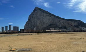
Then continuing towards Sevilia. Having visited Seville I headed towards the south coast to Cadiz passing the town Tariffa in the Cadiz in the Andalucia region of Spainis It is famous for its strong and constant winds, making it a paradise for kitesurfershe and from there I cycled along the coast towards Gibraltar known as “The Rock” or “Gib”, it is a corner of England that stands on a rocky promontory right in front of the African shore and in the Ascona Strait that connects the Atlantic Ocean and the Mediterranean Sea.
Visited Gibraltar I cycling along the Mediterranean coasts of: Costa de la Luz, Costa del Sol, Costa Granadina, Costa Almeria, Costa Cálida, Costa Blanca, Costa del Valencia, Costa Daurada, Costa del Maresme and Costa Brava.
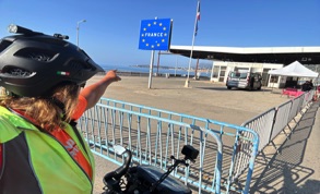
The end of my journey of my incredible and unforgettable journey in the Iberian Peninsula ended in La Jonquera s situated next to the border with Northern Catalonia, Spain and nowadays France.
The last real stage was to ride again along the French Riviera but I took the winding spectacular road La Grande Corniche is situated at an altitude of over 400 meters and is the oldest road, built under the orders of Napoleon 1st.
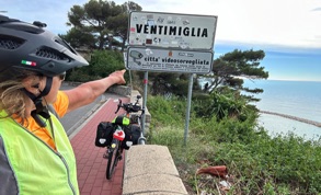
Then reached the starting point in Ventimiglia in the pretty tourist town in the province of Imperia, Liguria, Northern Italy. Goodbye trip and the train takes me back to Milan!
How did you plan your trip?
As an adventurer, who leaves completely independently, I have always found more interest in building my itinerary from one place to another. Of course as with all my trips I create in advance a map "based on the places that interest me" of the entire trip with online programs as a general reference point to have an idea of the route and distances.
I could certainly use the Garmin Connect tool "create routes" to upload a GPX to the memory of my Garmin GPS computer but I don't use it, I don't like being guided, it wouldn't be an adventure! So I recover my route only at the end of the day with my GPS cycling computers and also the apps that I use that indicate to me which road I really traveled that I only know at the end of every my cycling day where I really was!
Certainly I was aware of the Eruvelo cycle path of the Camino di Santigo or others but I hadn't downloaded the true route and it wasn't too difficult to follow them also because most of them ran along the coast and then as a reference there was the sea on my right or I found signs of the cycle paths!
There are several Apps I use Komoot, Strava, and Google Maps allows you to outline the lines of my itinerary and is a great solution for finding the fastest route between two stops and giving driving directions that I used every day.
In my experience with Google Maps, it is great for figuring out the route to the destination but I often had to abandon it because I found myself on rough dirt roads that were impassable. Regardless, you know the position of the moment you are and then I was able to change it with the orientation!
Therefore I did not study my stages in advance (certainly I would have done it on a trip like cycle tours in Canada USA or elsewhere due to the distance from one place to another). However every evening I planned my route for the next day looking at the Apps for information on the mileage, altitude differences and what type of accommodation I would find.
Which network roads used?
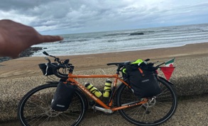
Having traveled with a cycle touring bike with fairly large tires that allow me to have an adventure on different types of terrain, from asphalt roads and dirt roads. I have always looked for less roads with low-traffic routes and/or roads with good shoulders, cycle paths, (EuroVelo cycle path of the Camino di Santiago or others) dirt paths and I also followed the routes that local people had recommended to me, they know them best! So I built vehicular roads only if it was not possible to do otherwise.
What can you tell us about the adventure cycling around the Iberian Peninsula?
It was an incredible and satisfying experience to enjoy every moment with nature appreciating the variety of landscapes.It allowed me to explore the whole Iberian Peninsula and discover places I had not cycled in Spain and Portugal and It also opens up a world of opportunities to build a deeper relationship with the locals and their culture and to meet other tourists.

ROUTE STAGE 2°: ITALY - FRACE
The first cycling stage in Provence-Alpes-Côte d'aAzur in the south of France from Ventimiglia, the border of Italy to River of Agly in southern France near the east of the Pyrénées-Orientales and the Mediterranean sea
ROUTE STAGE 3°: FRENCH PYRENEES
Cycling accrues the French Pyrenees from the Mediterranean Sea to the location of to the Atlantic Ocean. Cycling stage from Le Barcarès bordering the Mediterranean Sea to Hendaye with its feet in the Atlantic Ocean
ROUTE STAGE 4°: NORTHEN SPAIN
The cycling stage along the Atlantic coast of Spain from east to west leaving the Atlantic Ocean behind and after the inland stretch to Santiago de Compostela is located in the region of Galicia, on the north-western tip of Spain.
ROUTE STAGE 5°: PORTUGAL
Cycling stage from North to South and then the Algarve from West to East of Portugal
ROUTE STAGE 6°: PORTUGAL & SPAIN
Cycling stage from the border of Portugal to Vila Real de Santo António in the Algarve and crossing the River Guardiana via ferry to the town of Ayamonte province of Huelva, Andalusia in the southwestern Spain
ROUTE STAGE 7°: SPAIN & GIBRALTAR
Cycling stage from Ayamonte through to the Andalusia province on the southwestern Spain to Gibraltar, the British colony located on the southern tip of Andalusia.
ROUTE STAGE 8°: GIBRALTAR - SPAIN - BORDER OF FRANCE
Cycling stage from Gibraltar crossing Spain from West to East on the Mediterranean Coast to the French Border
ROUTE STAGE 1°: ITALY
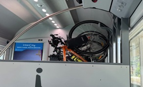
The first cycling stage consisted of taking the Train from Milan Central Station and after the 3 hour 44 minute journey to Ventimiglia Railway Station. Then cycled to th camping Rome in Ventimiglia in Ligurian Sea iin italy
ROUTE STAGE 9°: FRANCE BORDER & ITALY
Cycling stage from the France border to the Italian border in the city of Ventimiglia which overlooks the sea in the far western Liguria.
READ MORE
READ MORE
READ MORE
READ MORE
READ MORE
READ MORE
READ MORE
READ MORE
READ MORE
MAP coming soon
ALL THE STAGES OF THE TOUR AND VIDEOS.... Coming soon
Cycle Tour I Circumnavigation the Iberian Peninsula I Spain and Portugal
