

Hike to Monte Resegone – the “saw-toothed” mountain of Lecco (Lombardy, Italy)
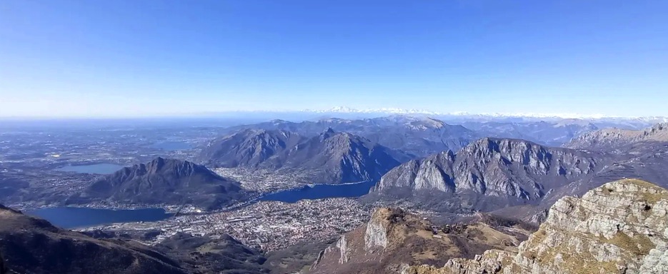
Monte Resegone is one of the most iconic mountains in Lombardy, famous for its saw-toothed shape, composed of around twelve main peaks aligned like the teeth of a blade, and for the spectacular views it offers over the Lombard plain, Lake Lecco, and surrounding Alps.
This is a medium-to-high mountain hike, challenging yet rewarding, ideal for those who enjoy steep trails, panoramic ridges, and breathtaking vistas, experiencing a true pre-Alpine adventure.
Ascent to Resegone – from start to summit
The hike begins at Piani d’Erna, easily reachable from Lecco by cable car, a classic starting point for numerous trails to the summit. At the base, there are refuges such as the Rifugio Piani d’Erna, perfect for a short stop or to admire the surrounding mountain scenery.
The initial section winds through beech and larch forests, with glimpses of the valley and Lake Lecco, hinting at the panoramic views to come. The main trail, n. 1, alternates soft sections with natural steps, rocky areas, and easy exposed passages. Along the way, you can see chalets and old alpine huts, remnants of traditional mountain life.
As the forest gives way to rock and ridges, hikers reach the famous saw-tooth ridge, with its twelve main peaks, where some sections require sure-footedness and attention.
Important note: the standard route from Piani d’Erna does not require ropes, even along the ridge. Ropes may only be necessary in snow, ice, or wet conditions, when exposed sections become more hazardous.
Before tackling the final stretch, hikers reach Rifugio Azzoni (1,796 m), the last refuge before the summit cross, an ideal place to rest, hydrate, and enjoy the view. From here, the trail continues along the rocky ridge to the main summit, marked by the cross, symbol of Resegone.
Panorama – Lake Lecco and surroundings
From the summit of Resegone, a spectacular 360° view opens up:
• North: the Orobie Alps, imposing and rugged
• East: Lake Lecco, the eastern branch of Lake Como, approximately 23 km long and narrow, nestled between the pre-Alpine mountains and the Lombard plain. The lake stretches like an arm toward the north, with the city of Lecco at its southern end.
From the summit, the lake appears at the base of the ridge, with its blue waters, villages along the shores, and surrounding hills and mountains reflecting in the water. The view highlights the contrast between the calm waters and the jagged Resegone ridge, creating a unique and striking panorama.
• South: the Lombard plain, green and dotted with villages and cultivated fields
• West: surrounding mountains, including smaller peaks and alpine valleys
Every detail – from meadows and forests to villages, alpine huts, and the lake – makes this hike unforgettable, offering one of the most celebrated panoramas of the Lombard Prealps.
Descent from Monte Resegone
The descent follows the same route as the ascent, allowing hikers to once again enjoy the forests, meadows, and alpine huts. Panoramic points along the ridge and rocky sections still offer glimpses of Lake Lecco and the surrounding mountains before returning to Piani d’Erna.
Cable car option: Those who prefer to shorten the descent or save energy can, once at Piani d’Erna, take the cable car back to Lecco, avoiding the final stretch on foot to the parking area.
Along the way, whether on foot or by cable car, hikers can still observe refuges, pastures, and alpine stables, where in summer cows, goats, and sheep graze, accompanied by the sound of cowbells and guardian dogs, providing a pleasant contrast between the effort of the climb and the relaxed atmosphere of the alpine pastures.
Conclusion
The hike to Monte Resegone is a complete experience: it combines physical challenge, spectacular scenery, and unique natural environments, across forests, rocky ridges, and alpine refuges. From the summit, hikers can admire Lake Lecco, the Orobie Alps, the Lombard plain, and surrounding mountains, enjoying a true pre-Alpine panoramic balcony.
This hike rewards the effort with breathtaking views, perfect for experienced hikers seeking an authentic alpine adventure, combining nature, history, and mountain tradition.
📌 Trail Details
• Start / Finish 📍: Piani d’Erna (Lecco, Lombardy, Italy)
• Distance 🥾: approx. 12–14 km round trip
• Elevation gain ⛰️⬆️ : approx. 1,000 m
• Estimated duration ⏱: 5–7 hours
• Summit altitude ⛰️: 1,875 m
• Difficulty 💪: EE / E (Experienced Hikers; exposed ridge sections)
• Terrain / trail 🛤️ : mountain trails, rocky areas, ridge, forest
• Refuges along the route: Rifugio Piani d’Erna (start), Rifugio Azzoni (last refuge before summit cross)
• Panorama & environment: Lake Lecco, Lombard Prealps, Orobie Alps, alpine meadows and forests
• Map 📍: View map – Coming Soon