

Cycle Tour | Circumnavigation of the Iberian Peninsula: from the Mediterranean to the Atlantic and Back – Stage #3
🇫🇷 Stage 3: French Pre‑Alps / Pyrenees
From the Mediterranean Coast to the Atlantic Coast
Crossing the eastern slopes of the French Pyrenees, the route winds along the foothills of the Pyrenean mountain range, following the V81 Piémont Pyrénéen, also known as Vélosud. It is not a rigid line, but an itinerary that follows the mountains, always maintaining the main direction: from coast to coast, from the Mediterranean of Leucate and Le Barcarès to the Atlantic coast at Bayonne, near the confluence of the Nive and Adour rivers, and finally reaching the Atlantic Ocean at Biarritz.
The route reaches Hendaye, a town on the Spanish border, where the Bidasoa bridge leads to Irun, the gateway to the Camino del Norte (coastal pilgrimage route ) and the entrance into the Spanish Basque Country.
The Vélosud crosses the departments of Pyrénées-Orientales, Aude, Ariège, Haute-Garonne, Hautes-Pyrénées, and Pyrénées-Atlantiques, covering approximately 650 km. The route favors quiet, low-traffic roads, crossing open valleys and rolling hills, offering a constant and majestic view of the Pyrenean chain on the horizon.
The landscape gradually changes: from the dry, luminous Mediterranean vegetation, it shifts, kilometer by kilometer, to the green, wet, and rainy forests of the Atlantic side. The elevation profile is a continuous dialogue between flat stretches and hilly sections: it is never completely flat, with frequent, often steep climbs, testing both legs and concentration.
The mountains rise like silent guardians, and the terrain challenges both strength and determination, with climbs and descents that remind why I love mountain cycling. Every hairpin bend reveals dramatic valleys, rushing streams, and jagged peaks, making every pedal stroke intense and rewarding.
│ «In the Pre-Alps, the mountains speak in silence, but their challenge is a conversation no cyclist can resist.»
🇫🇷 Stage 3.1 | Day 9: Camping Cap Leucate, Leucate → Camping de l'Agly, Saint‑Paul‑de‑Fenouillet, France
From the Mediterranean Coast to the Foothills of the French Pyrenees – Pyrénées‑Orientales, Occitania
This morning I woke up to sunshine and mild temperatures. After taking down the tent and packing my gear, I exchanged a few words with German, the cyclist I met the previous evening, before setting off with Girasole, the name I gave my bike, engraved on the frame.
The EuroVelo 8 soon led me to Le Barcarès, a small coastal village nestled between the wide Mediterranean beaches and the first slopes of the Eastern Pyrenees. From here, I joined the Piémont Pyrénéen (V81, Vélosud), the long-distance cycle route crossing the French Pyrenean foothills, connecting the Mediterranean to the Atlantic.
From Le Barcarès, I cycled towards Claira and Rivesaltes along the Via Verde that follows the Agly River. The scenery was breathtaking: on one side, sparkling water, on the other, endless orchards, with my gaze reaching Mont Canigou, rising majestically on the horizon.
The Vélosud then continued gently uphill through Peyrestres, Cases-de-Pènes, and Estagel, leading me to Saint‑Paul‑de‑Fenouillet, a small rural gem in the heart of the Fenouillèdes region, in the Pyrénées-Orientales department, Occitania.
In the evening, I reached Camping de l'Agly, where the very kind lady at the reception welcomed me warmly and showed me a shaded pitch. The campsite, situated between the Agly River, the surrounding mountains, and the village shops, was the perfect place to rest after a long day of cycling.
As night fell, I washed my clothes, prepared a simple dinner, and replied to some messages from family and friends. Then I studied the map for the next stage before falling asleep under the clear Pyrenean sky.
📌 Route information and footage with GoPro
• Region / Area 🌍: Pyrénées‑Orientales
• Main Locations 🏘 :Leucate → Le Barcarès → Claira → Rivesaltes → Peyrestres → Cases-de-Pènes → Estagel → Saint‑Paul‑de‑Fenouillet
• Distance 🚴 : ~81.3 km
• Total Time ⏱️ : [.....], including scenic and photo stops
• Terrain 🛣️ : Paved roads and cycle paths, gentle to moderately challenging climbs, valleys and hills of the eastern Pyrenees
• Direction 🧭 : East → west, from the Mediterranean coast to the eastern foothills of the French Pyrenees
• Route Map 📍: View the map
🇫🇷 Stage 3.2 | Day 10: Camping de l'Agly, Saint-Paul-de-Fenouillet → Hotel Castel d'Olmes, Laroque-d'Olmes, France
Occitanie: France Gorges de la Pierre-Lys, valleys and small villages
The day began under a light blanket of clouds. After my usual routine at the campsite, I greeted with a smile the kind woman at the reception, whose warmth had impressed me during my stay. A quick photo and a hug, and then I set off to tackle today’s route.
I followed the D117, a secondary road promising a twisting and fascinating itinerary through the Gorges de la Pierre-Lys, a section I had long wished to explore. The road rose gently among green hills and farmland, never steep, with the high peaks of the Pyrenees standing majestically on the horizon in the distance.
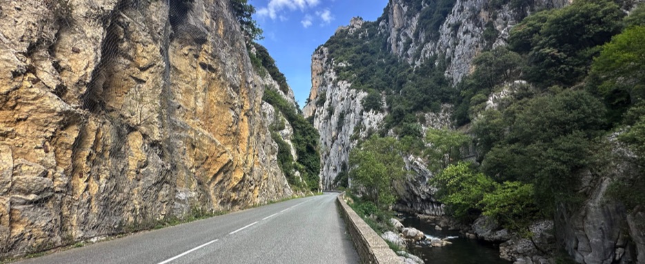
Passing through Caudiès-de-Fenouillèdes, I reached Saint-Martin-Lys, a small village at the entrance of the gorge. From there, the route plunged into the heart of the Gorges: the Aude River rushed below me, between towering rock walls and spectacular cliffs. Every hairpin bend revealed postcard-worthy views, making each pedal stroke a reward for the effort.
In Quillan, I stopped at a well-kept rest area, complete with toilets and informational panels about the area. After a short break, I resumed climbing at a steady pace, through increasingly rugged and wild landscapes. Finally, I reached the Col du Portel at 601 meters above sea level.
From there, the road continued along the ridge with gentle descents, passing through Brenac, Puivert, Bélesta (on the banks of the Hers-Vif), L’Aiguillon, Saint-Jean-d’Aigues-Vives, and Lavelanet, before arriving at Laroque-d’Olmes, a small town in the Ariège department, in the Occitanie region.
In Laroque-d’Olmes, I stayed at the Hotel Castel d’Olmes, a small family-run hotel with a pool and a restaurant(closed that evening). With no other nearby options, I was grateful for the emergency supplies I always carry in my backpack, which proved perfect for dinner. Sitting by the window, I enjoyed a simple meal while listening to the rain falling, happy not to be in a tent and already ready to plan the next stage.
The evening ended with messages sent to family and friends, and a quick check on Google Maps and Komoot to prepare for the following day, under the clear Pyrenean sky.
📌 Route information and footage with GoPro
• Region / Area 🌍: Ariège
• Main Locations 🏘 : Saint-Paul-de-Fenouillet → Caudiès-de-Fenouillèdes → Saint-Martin-Lys → Belvianes → Quillan → Col du Portel → Brenac → Puivert → Bélesta → L’Aiguillon → Saint-Jean-d’Aigues-Vives → Lavelanet → Laroque-d’Olmes
• Distance 🚴 : ~76.9 km
• Total Time ⏱️ : [.....], including scenic and photo stops
• Terrain 🛣️ : Secondary hilly roads, Gorges de la Pierre-Lys, gentle climbs and mild descents, rural landscapes and villages
• Direction 🧭 : East → West, crossing the valleys and eastern foothills of the Pyrenees
• Route Map 📍: View the map
🇫🇷 Stage 3.7 | Day 15: Hotel Labat, Orthez → Camping Alturaran, Hendaye, France Nouvelle-Aquitaine, France
From inland to the Atlantic coast, along rivers and beaches
The day began under a blanket of gray clouds, with rain looming on the horizon. After breakfast at Hotel Labat, I set off on my bike, cycling through Orthez and crossing Le Pont Vieux, a charming 13th-century medieval bridge. Its asymmetrical arches and fortified tower rose elegantly above the Gave de Pau River, silent witnesses to centuries past.
Beyond Orthez, the cycle path led me through the rain-kissed countryside of Sainte-Suzanne, Salles-Mongiscard, Bellocq, and Lahontan. The landscape was lush and green, with the drizzle softening every outline. Gradually, the clouds began to break, revealing patches of blue sky, and the road opened onto vast agricultural plains: wheat fields and golden sunflowers swaying gently in the wind.
Following the Adour River, I glimpsed the Basque Mountains in the distance, passing through Urt and Urcuit, and finally reaching Bayonne, located at the confluence of the Nive and Adour rivers, just a few kilometers from the Atlantic coast. Leaving the town, I cycled along the left bank of the Adour near the Brise-Lames marina, where the river meets the ocean.
Soon I arrived at the Anglet coast, a stunning stretch of untouched sandy beaches where the Atlantic waves foamed and crashed onto the shore. Here, I felt the full joy of this sea-to-sea adventure—every pedal stroke had been worth it.
Continuing along the scenic Basque coastline, I passed through Biarritz, Bidart, Guéthary, Saint-Jean-de-Luz, and finally Hendaye, the last French town before the Spanish border. Perched on the edge of northern Basque Country, Hendaye is where land meets the wild Atlantic with grace.
By the time I reached Camping Alturaran, the rain had returned. I quickly set up my tent, covered my bike with a tarp, and picked up a simple dinner at the campsite market: a can of beans, enjoyed warm inside the tent. But the rain couldn’t stop me.
I stepped out toward the beach, where waves thundered along the long, empty sand. Even under the gray sky, Hendaye held a romantic beauty, with mist and sea creating a timeless scene.
Back in the tent, map in hand, I planned the next stage. France had been magnificent—full of history, flavors, and landscapes that left me breathless. I sent a few messages to family and friends before letting myself drift to sleep, ready to cross into Spain and continue my journey along the wild northern coast of the Iberian Peninsula.
📌 Route information and footage with GoPro
• Region / Area 🌍 : Pyrénées-Atlantiques, Nouvelle-Aquitaine
• Main Locations 🏘 :Orthez → Sainte-Suzanne → Salles-Mongiscard → Bellocq → Lahontan → Urt → Urcuit → Bayonne → Anglet → Biarritz → Bidart → Guéthary → Saint-Jean-de-Luz → Hendaye
• Distance 🚴 : ~113 km
• Total Time ⏱️ : [.....], including scenic and photo stops
• Terrain 🛣️ : paved roads, cycle paths, flat stretches along rivers, Atlantic coast
• Direction 🧭 : East → West
• Route Map 📍: View the map
🇫🇷 Stage 3.3 | Day 11: Hotel Castel d'Olmes, Laroque-d'Olmes → Hotel/Camping Parc de Palétès, Saint-Girons, France
Occitanie – Valleys, villages, and Pyrenean landscapes
I woke up and pulled back the curtains: rain was falling steadily on the window, just as predicted. Fortunately, breakfast was included: coffee, croissants, bread, and jam—simple but perfect to start the day.
During breakfast, I chatted briefly with the hotel owner, who told me about his Italian roots. A short conversation, then it was time to leave.
I retrieved Girasole from storage and, well-prepared for the rain, started cycling along the D117, a quiet, almost traffic-free road. The climb was slow but steady, surrounded by green and silent landscapes, passing through Laroque-d’Olmes, Dreuilhe, Lavelanet, and Nalzen.
From here, the clouds began to break, letting in some light. The road descended gently toward Celles, Saint-Paul-de-Jarrat, and Montgailhard, leading me to Foix, a charming medieval village dominated by its hilltop castle at the confluence of the Ariège and Arget rivers.
Leaving Foix, I alternated between the D117 and the V81 bike path, both smooth and immersed in nature. The climb continued up to Col du Bouich (599 m) near Saint-Martin-de-Caralp, then turned into a long descent through La Bastide-de-Sérou, Castelnau, and Durban.
A final short climb preceded a quiet descent to Lescure, where the landscape opened up to the beautiful Barguillère Valley: green pastures, grazing animals, and mountains in the background.
In the afternoon, I reached Saint-Girons, in the heart of the Ariège Pyrenees. A few kilometers from the center, I arrived at Camping Parc de Palétès, a green and well-equipped site.
With rain still falling and worse forecasts for the night, I opted for a room instead of the tent. The space was simple but cozy, with a balcony overlooking the valley and the steady sound of rain creating a relaxing atmosphere.
After settling in, I went down to the campsite restaurant for dinner, where I was greeted by a beautiful beige cat, a quiet and curious presence throughout the evening. Back in my room, I checked the map for the following day and fell asleep, accompanied by the steady rhythm of the rain.
📌 Route information and footage with GoPro
• Region / Area 🌍: Ariège (Occitanie, France)
• Main Locations 🏘 :Laroque-d’Olmes, Lavelanet, Nalzen, Foix, La Bastide-de-Sérou, Saint-Girons
• Distance 🚴 :~~141 km
• Total Time ⏱️ : [.....], including scenic and photo stops
• Terrain 🛣️ : Hilly and mountainous, steady climbs and long descents
• Direction 🧭 : East → West, from Laroque-d’Olmes to Saint-Girons
• Route Map 📍: View the map
🇫🇷 Stage 3.4 | Day 12: Hotel/Camping Parc de Palétès, Saint-Girons → Camping Les Craouès, Capvern, France
Occitanie, France Valleys, villages, and Pyrenean landscapes
The day started in the best possible way: opening the curtains, I was greeted by bright sunshine, a surprise after the rain predicted the night before. With the bike already ready in the room, departure was quick and stress-free.
After a simple but perfect breakfast at the campsite, I set off through Saint-Girons, crossing the Salat River and cycling toward Caumoni, Castagnède, and Mane, immersed in increasingly green and quiet landscapes.
Back on the V81, cycling along country roads and cultivated fields, I passed through Lestelle-de-Saint-Martory, getting back on track after a short detour. Sunflower fields and the morning light made everything particularly picturesque.
At Labarthe-Inard, I crossed paths with other cyclists, and shortly after, passing through Estancarbon, the climb became more challenging, among wheat fields and grazing horses, until reaching the surroundings of Saint-Gaudens.
From here, I followed the D817, passing through Valentine, where I stopped briefly at the market. The route continued through peaceful countryside, hay bales, and secondary roads, passing Huos, Montréjeau, and Pointis-de-Rivière, where I exchanged a few words with another cyclist I met along the way.
The final part of the stage led me through Cantous and Mazères-de-Neste, with mountains in the background and an almost complete silence around.
In the late afternoon, I arrived at Capvern, in the heart of the Hautes-Pyrénées. Camping Les Craouès, almost empty due to the low season, offered covered pitches perfect for spending the night dry, just as the sky began to change again.
A day of calm rhythms, quiet roads, and open landscapes in the authentic heart of the French Pyrenees.
📌 Route information and footage with GoPro
• Region / Area 🌍: Hautes-Pyrénées
• Main Locations 🏘 :Saint-Girons → Caumoni → Castagnède → Mane → Lestelle-de-Saint-Martory → Labarthe-Inard → Estancarbon → Saint-Gaudens → Valentine → Huos → Montréjeau → Pointis-de-Rivière → Cantous → Mazères-de-Neste → Capvern
• Distance 🚴 : ~86.6 km
• Total Time ⏱️ : [.....], including scenic and photo stops
• Terrain 🛣️ : Quiet secondary roads, gentle to moderate climbs, valleys and countryside of the Pyrenees
• Direction 🧭 : East → West, from the Ariège Pyrenees to the Hautes-Pyrénées
• Route Map 📍: View the map
🇫🇷 Stage 3.5 | Day 13: Camping Les Craouès, Capvern → Hotel Monfort, Lourdes, France
Occitanie, France - Green hills, rural villages, and Pyrenean spirituality
It rained all night. Luckily, I had pitched my tent under one of the covered structures at the campsite. I couldn’t start as early as I wanted: the rain was heavy, but after about an hour, the sky began to clear, and I was able to take down the tent completely dry, grateful for the shelter I had chosen under those structures, now closed for the season.
I set off under a cloudy sky with a light drizzle that accompanied me for much of the day. I left Camping Les Craouès, riding along quiet country roads, gently downhill, among green hills dotted with small houses. It didn’t feel like summer, but more like a gray, misty winter morning.
Crossing Molère, the village was completely deserted, immersed in absolute silence. Shortly after, I reached Mauvezin, a charming village in the heart of the Hautes-Pyrénées countryside, with narrow streets framed by lush mountains. In Castillon, I saw the only car I would encounter for some time: the driver slowed to warn me about a free-roaming bull nearby. I scanned the roadside but saw no trace of it.
The rain stopped, and I continued along narrow, quiet roads. A friendly dog suddenly appeared and ran ahead of me for a stretch, almost guiding me or testing me along a climb, before disappearing, leaving me alone among rolling hills and pristine nature.
Passing through a series of small villages, always downhill, I arrived at Montgaillard, where a sign indicated the Sentier pieds nus (barefoot trail), a sensory path designed to reconnect with nature. The idea was tempting, but the road called me. I continued through Loucrup and Escoubès-Pouts until I finally reached the day’s destination: Lourdes.
I had already been to Lourdes on another cycling trip, but it’s one of those places that always retains its charm. It conveys a sense of balance between architecture, spectacular landscapes, and the collective energy of the place, leaving the mind calm and the spirit light.
I checked in at Hotel Monfort, where the lady at reception welcomed me warmly. My bike had a safe spot inside, and my room had a balcony with a distant view of the Sanctuary of Our Lady of Lourdes.
With the rain still present, I put on my jacket and went down into town. The Lourdes Castle stood tall above, watching over the city and the Sanctuary. At the Grotto of Massabielle, pilgrims were filling bottles with holy water from the fountains. I had promised family and friends I would bring back some blessed water, so I bought a few small bottles at a souvenir shop.
Back at the Sanctuary, the evening torchlight procession had already begun, and the only way to reach the fountains was to join the procession. And that’s what I did: I walked with the pilgrims until I finally managed to fill the bottles.
When I returned to the hotel, it was later than planned, but I had kept my promise. Space in my bags was limited, but I would find a solution. The forecast predicted more rain for the following day. I checked my map for the next destination, then closed my eyes and drifted off to sleep, grateful for another day of travel among nature, villages, and small adventures.
📌 Route information and footage with GoPro
• Region / Area 🌍: Hautes-Pyrénées (Occitanie, France)
• Main Locations 🏘 :Capvern (Camping Les Craouès) → Molère → Mauvezin → Castillon → Montgaillard → Loucrup → Escoubès-Pouts → Lourdes
• Distance 🚴 : ~85 km
• Total Time ⏱️ : [.....], including scenic and photo stops
• Terrain 🛣️ : Quiet paved secondary roads, gentle rolling climbs, scenic descents, rural villages
• Direction 🧭 : Northwest, through valleys and hills toward Lourdes
• Route Map 📍: View the map
🇫🇷 Stage 3.6 | Day 14: Hotel Monfort, Lourdes, France →Hotel Labat, Orthez, France
Nouvelle-Aquitaine, France – From inland to the Atlantic coast, between rivers and beaches
The day began under a blanket of gray clouds, a sky heavy with rain on the horizon. After breakfast at Hotel Labat, I set off by bike, crossing Orthez and riding over Le Pont Vieux, a charming 13th-century medieval bridge. Its asymmetrical arches and fortified tower stood elegantly above the Gave de Pau River, silent witnesses of centuries past.
Beyond Orthez, the cycle path led me through rain-soaked countryside, passing Sainte-Suzanne, Salles-Mongiscard, Bellocq, and Lahontan. The landscape was lush and green, softened by a light drizzle that blurred every outline. Gradually, the clouds began to break apart, revealing patches of blue sky, and the road opened into wide agricultural plains: fields of wheat and golden sunflowers gently swaying in the wind.
Following the Adour River, I could see the distant Basque mountains ahead, riding through Urt and Urcuit before reaching Bayonne, located at the confluence of the Nive and Adour rivers, just a few kilometers from the Atlantic coast. Leaving the city, I cycled along the marina on the left bank of the Adour, where the river meets the ocean.
Soon, I reached the coast at Anglet, a stunning stretch of wild sandy beaches where the Atlantic crashed into the shore with foaming waves. In that moment, I felt the full joy of this sea-to-sea journey: every pedal stroke had been worth it.
Continuing along the scenic Basque coastline, I passed through Biarritz, Bidart, Guéthary, Saint-Jean-de-Luz, and finally Hendaye, the last French town before the Spanish border. Set at the edge of the northern Basque Country, Hendaye is where land meets the wild Atlantic with quiet elegance.
When I arrived at Camping Alturaran, the rain had returned. I quickly pitched my tent, covered the bike, and bought a simple dinner at the campsite market: a can of beans, enjoyed warm inside the tent. But the rain couldn’t stop me.
I walked down to the beach, where waves thundered along the long, empty shoreline. Even under the gray sky, Hendaye had a romantic beauty, with mist and sea blending into a timeless scene.
Back in my tent, map in hand, I planned the next stage. France had been incredible full of history, flavors, and breathtaking landscapes. I sent a few messages to family and friends before drifting off to sleep, ready to cross into Spain and continue my journey along the wild northern coast of the Iberian Peninsula.
📌 Route information and footage with GoPro
• Region / Area 🌍: Pyrénées-Atlantiques, Nouvelle-Aquitaine
• Main Locations 🏘 :Lourdes → Pau → Artiguelouve → Morlaas → Mont-Lendesse → Orthez
• Distance 🚴 : ~~94.4 km
• Total Time ⏱️ : [.....], including scenic and photo stops
• Terrain 🛣️ : Paved roads, cycle paths, gentle descents, mostly flat stretches along the river
• Direction 🧭 : East → West
• Route Map 📍: View the map